Updated Tuesday 9 September Ike appears non-threatening to our area.
Updated Monday 8 September Ike continues to move Westward toward us.
Updated Sunday 7 September Ike has moved Westward towards us.
Updated Thursday 4 September Ike is a potential threat, a long way out.
Although the forecasts and models still do not predict that Ike will strike Belize, I am even more concerned by the Western movement of the Hurricane which was also not predicted by the earlier forecasts and models.
5 day projected path and position from Weather Underground.
Computer model forecast from Weather Underground.
The models and the official forecast have always been saying the storm would move North West. Yet, Here Ike is close to 20deg North latitude as he was maybe a week ago. We are at 18degN latitude. Ike has now crossed Cuba, it was supposed to stay North, but it is now South of Cuba. Despite where it is supposed to go, this storm is moving West.
Forecaster discussion from Weather Underground.
According to a recent Forecast discussion, Cuban radar shows Ike moving West:
Cuban radar and visible satellite imagery indicates that Ike
continues moving westward or 270/12. Track guidance remains in
good agreement that Ike will soon turn west-northwest and track
along or just south of Cuba for the next 12 to 24 hours. This
requires a slight southward shift to the official track through 36
hours. Dynamical models are still forecasting a shortwave trough
to move over the eastern United States in a couple of days
resulting in some weakening of the ridge to the north of Ike.
This is expected to cause Ike to turn temporarily to the northwest
with a reduction in forward speed. All models forecast the
shortwave to bypass Ike to the north...and are now in much better
agreement that Ike will turn slightly westward in about 3 days.
This turn is reflected in the official forecast. However...much
uncertainty remains regarding the strength of the mid-level ridge
which builds in the wake of the exiting shortwave.
Graphic by: Naval Atlantic Meteorology and Oceanography Center

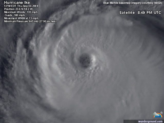
Satellite image centered on Hurricane Ike:

-----------------------------------

Ike hasn't even entered the Caribbean yet. Ike is already North of us. It would have to move Southward to hit us. Historically this has not happened before with a storm of Ike's position and time of year.
Ike is not pointed at us, Ike isn't supposed to come here.
I don't know why, but I don't like Ike. I wouldn't say I'm frightened, just that I have the sense that I will be. I will feel much better if Ike continues on the path the experts say it will follow.


Updated Thursday 4 September:
Ike has become a cat 4 Hurricane, it is expected to fluctuate in intensity. It has also turned or is soon expected to turn somewhat to the South.
The Naval Research Laboratory at Monterey has plotted this path for Hurricane Ike. Belize is not on this map.

The people who fly airplanes into Hurricanes publish their measurements after each flight. Below is part of an old discussion.
The initial motion estimate is 295/15. The track guidance agrees
on a continued west-northwestward motion during the next 24 hours.
During the middle portion of the forecast period...a mid-level
ridge is expected to build to the north of the cyclone...and the
models unanimously respond by turning Ike west-southwestward. The lingering question that remains at the longer range is when Ike
will move around the western periphery of the ridge. The
model spread remains quite large at days 4 and 5. The GFDL is on
the left side of the guidance with a track near Hispaniola and
eastern Cuba...while the GFS and UKMET show a position to the
northeast of the Bahamas. For now...the official track is between
these possible solutions and is in best agreement with the
HWRF...the 12z ECMWF...and the model consensus.
No comments:
Post a Comment